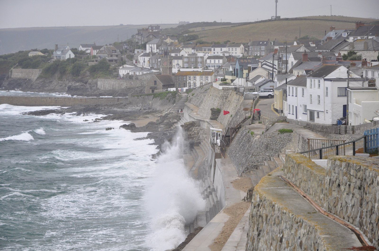
Porthleven is a cute village by the sea in Cornwall. One of many vibrant fishing villages turned tourist town in summer and (I assume) fairly slumbering in the winter. White masonry houses, steep cliffs, a bay harbor behind solid walls that remind us how wild the English Channel can be.
The better half is an architect and we biked to Porthleven to see the cute village. Porthleven turned out as what can best be described as shabby-chic-restored-cosy, and you can look at the pictures to prove it. But there was a nice surprise for me, the geologist, as well.

Down on the beach, the red flag flying and waves hammering, the rocks show a coffee-table book example of metamorphosis; how heat and water can change rocks. Nerdgasm!
Take a closer look at the pictures. What do you see? In mugglish, white bands with grey rims, towards thicker brown-grey bands. Like a sandwich of thin, light ham pieces between thick rye bread slices. Then, a big knife has cut through the whole thing, but the knife must have been quite blunt, since the scarp is irregular, crunched and full of dark gravy (or, Heaven forbid, Marmite).
Have a look at Mines, men and clotted cream in Cornwall!
Geo-wise, the white layers are the older, thin layers of shale and a bit of limestone. Upon close look, they are composed of lots of very thin layers. These are the original sediments that once settled in the sea, on the edge of a continent, in the Middle Devonian – around 380 million years ago. Then, volcanism woke up a little away, and sent octopus arms of igneous rocks into the sediments, following the layers with least resistance, and fried the white shale layers, so the edges became grey.

White shale layers, fried grey on the edges by the Brown dolerite intrusions, and cut by the fault to the right.
Igneous rocks are like children, the dearer the more names. The names are based on their mineral composition and classifies in the geekily named QUAPF or Streckeisen triangles. Mineral content can be difficult to assess without chemical analysis, but judging from the looks, I think the intrusives in Porthleven are dolerite, a fine-grain gabbro rock composed mainly of fine-grained plagioclase-feldspar, some pyroxene and some other minerals thrown in as spices.
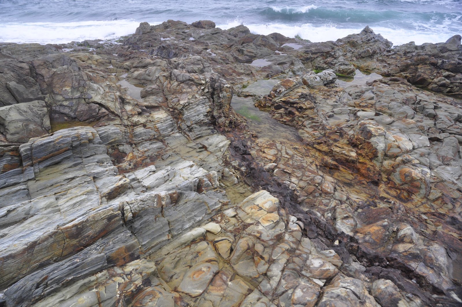
A closer look at the brown dolerite intrusions, and the dark zones of crushed fault rocks that cuts through the rock sandwich.
Then, the whole stack of rocks got tilted by the Variscian orogeny, when, basically, North America, Scandinavia, the Baltics and the-not-so-United Kingdom crashed into France (not the last time!), and southern Europe – and built a mountain chain.
One day later, may be in the last spasms of the Variscian, faults and fractures opened in the rock. They ground the rock to a fine mass called cataclasite in the zones with most deformation, while fractures around connected together to a network of veins, in which water with gases and dissolved elements could float through. The cataclasites are dark, fine grained masses, and the fracture fluids boiled the sediments and changed their colour into dark brown and black. Often – although not here – such fault zones contain ore deposits from metals brought in with water through the fractures.

Close-up of the fault zone, with almost black, crushed fault rocks and the fractures around stained brown by minerals precipitated from circulating water.
Sure, this story is simplified, might raise the eyebrow of a geochemistry pedant (you need to be a pedant to be a geochemist, because geochemistry is very nerdy). But I think this outcrop on the beach of Porthleven shows very well how one can read quite a bit of geological history, and how rocks develop, out of one small spot.
And then, we had a good gammon steak at the Harbour Inn.

Porthleven harbour, well protected from the wild sea. The Harbour Inn to the left.
Now, time for geologists to speak their opinion: The intrusives look like they are parallel with the sediments (in geo-speak: sills), but could it also be that they came later, at the same time as the big granites that created the mineral wealth of Cornwall?
I have a keen, and very amateur interest in geology and after a holiday in Porthleven last year I was interested in the dark veins cutting through the rock on the beach (as in your pictures). I assumed these were iron ore bearing and took some home with me.
Today as an experiment I build a simple blast furnace and smelted them (thinking them iron bearing). I succeeded in producing a good quantity of glass clinker and can now definitely confirm that they don’t contain significant amounts of iron!
Thanks very much for your article above and I thought you would be interested in my experiment today.