The sun sets into the Atlantic Ocean. In the distance is the eternal sound of the waves, one after another dashing onto the beach. I sit on the hotel balcony on La Palma, the western of the Canary Islands. On the table, a glass of chilled white wine.
An evening in paradise?
The islanders on La Palma call their island La Isla Bonita, the beautiful island. Indeed, it is. La Palma is lush, green, perfect climate, and grows its own bananas, mangoes, papaya, avocado…
But, beauty does not equal wealth. Rich in greens did not translate into rich in money. For people living on this less-visited Canary Island, life has often been hard, until income came also from tourism – and European Union subsidies.
The challenge of volcanoes adds on: I sit only six kilometers from the cone of the Tajogaite volcano, the last eruption in the Canaries. In 2021, Tajogaite spewed lava for 85 days, a small eruption in the big picture, but it drowned the whole town of Todoque with three thousand buildings in lava, and left seven thousand people homeless. “Luckily”, thanks to early warnings, only one person died, from gas poisoning, but the eruption left deep economic and emotional scars.
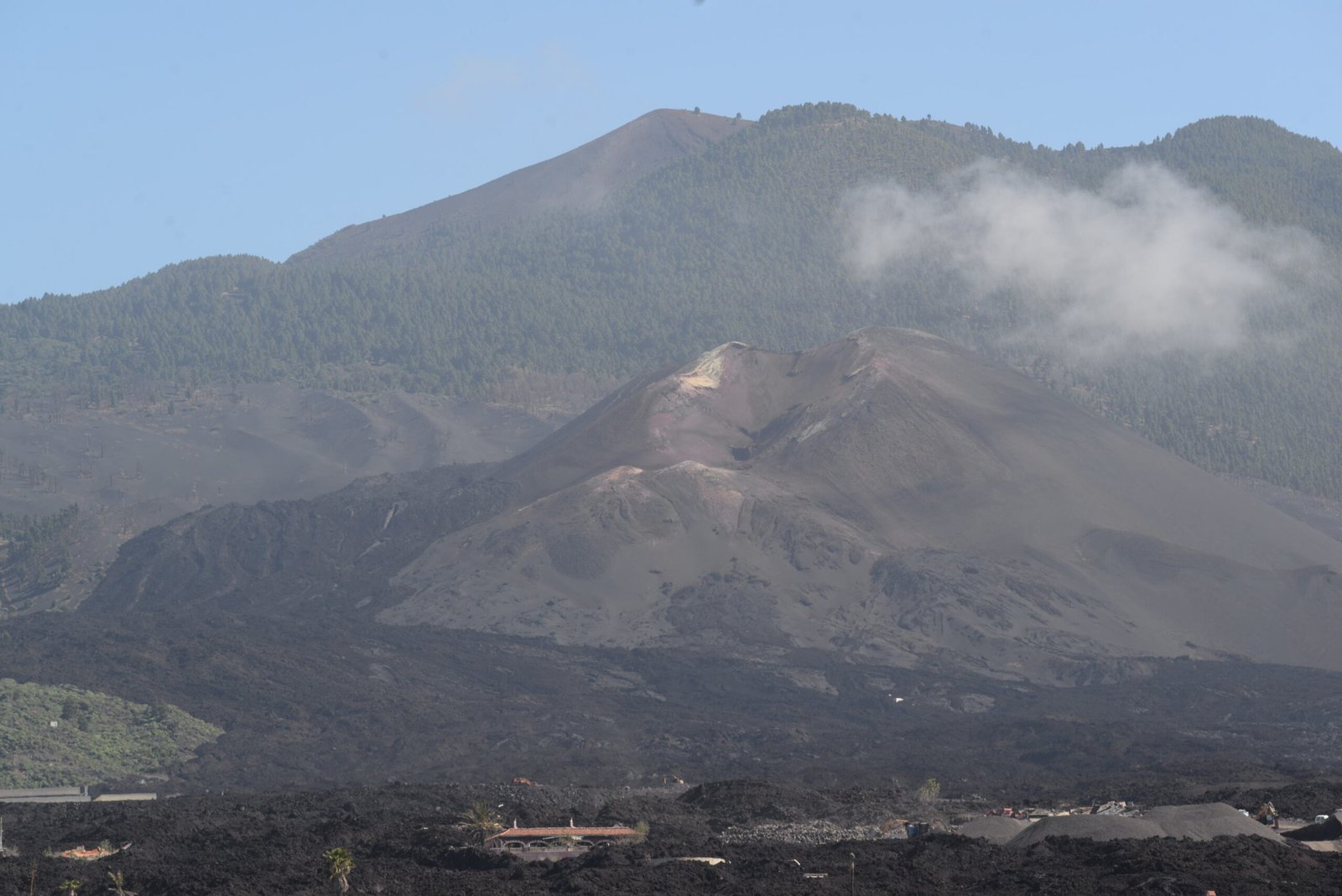
Tajogaite volcano, seen from the outskirts of Los Llanos. Dynamite and bulldozers have taken up the fight against the lava.
The Canaries are somewhat like the Icelanders: after volcano trouble, they pull up the sleeves, start rebuilding, and never miss the opportunity to turn their volcanoes into tourist attractions. New buildings rise on the lava. A new visitor center with information on the eruption and guided tours is already in place.
But one important thing differs: In contrast to Iceland, which almost bathes in geothermal heat and in electricity, the Canaries have never been able to harness the volcanoes’ enormous power for…power. In fact, save some solar and wind, the Canaries depend on imported oil and gas for energy.
Why?
Iceland and the Canaries are both volcanic hotspots. But Iceland is a big island in the North Atlantic, with North Atlantic weather and heavy rainfall. The rain fills the rivers, and hydropower still provide ca two-thirds of Iceland’s electricity. The water also sinks into the ground, where it is heated, and then brought back through fracture systems. Thus, Icelanders heat their homes with warm ground water, and almost every village has a naturally heated pool.

Hot springs in Haukadalur – a.k.a. Geysir, in Iceland. The geyser Strokkur blows every five to ten minutes. Nice to look at, slightly impractical for energy production.
The remaining third of Iceland’s electricity is made by geothermal power plants, located along the rift zone that goes along the island from southwest to north. Here, the crust is at its thinnest and the heat flow is so strong, that the wells can tap boiling water, which drives steam turbines.

Transformers are coming! Like silent giants, pylons hold in their arms the cables that distribute electrical power across from the Hellisheidi geothermal power plant to Reykjavik, in Iceland.
The Canaries do not have this water luxury. The islands are typically notably lush green on the north and western side, but arid and brown on the south and eastern side. This is because the left and upper sides face the trade winds, and captures the moist carried by the winds. Most of this moist settles as condensation on the vegetation, and then goes into the ground, finally emerging as springs or ground water. This is the case for La Palma, Tenerife, La Gomera, El Hierro and Gran Canaria. The easternmost islands, Lanzarote and Fuerteventura, on the other hand, are mostly desert, because they are to the east of the main winds, and are so worn down, they do not have any topography to catch the moist.
There are only a few rivers and streams on the islands. Most water is collected as ground water, collected by digging tunnels into porous layers of volcanic tuff. Demands from tourism and water-thirsty banana plantations have put a strain on the ground water resources, to the extent that desalination of seawater now contributes at least one quarter of the fresh water supply, using over one-tenth of the electricity production.
The pools of countless hotels and holiday homes patio are pretty, but also a squander of a limited natural resource. The pool water at our hotel tastes a bit brackish, so it was probably made with imported fossil fuels.
Hence, the lack of water going down also means no heating or electricity production by hot water going up.
The Canaries also have another issue: It is not hot enough down there.
Iceland sits on one big hotspot, straddling the mid-ocean ridge, and is slowly torn and re-built in the middle, by the rift zone, where the crust is thin.
The Canaries are more complicated. There is no rift zone or super-thin crust. The islands are, overall, oldest in the east and youngest in the northwest, and thus resemble a classic hotspot island chain. But there are devils in the details. Gran Canaria and La Gomera are both “old” and mainly inactive, torn down to look like round, giant fruit-squeezers. Tenerife is older in the north, while the mighty Teide volcano still is regarded as active. Its last eruption near the summit was in 1798, and as late as 1909, there was a fissure eruption in the southwest of the island. And old Lanzarote in the northeast experienced eruptions, in 1824 and a series of eruptions from 1731 to 1736, which devastated the island.
La Palma itself is actually two parts; the almond, or drop, shape of the island comes is made by a round older, eroded northern part, with all the eruptions in historic time taking place along a younger rift zone, making the tip towards the south. Within the overall westward-younging trend, the volcanism seems to jump back and forth. Why?
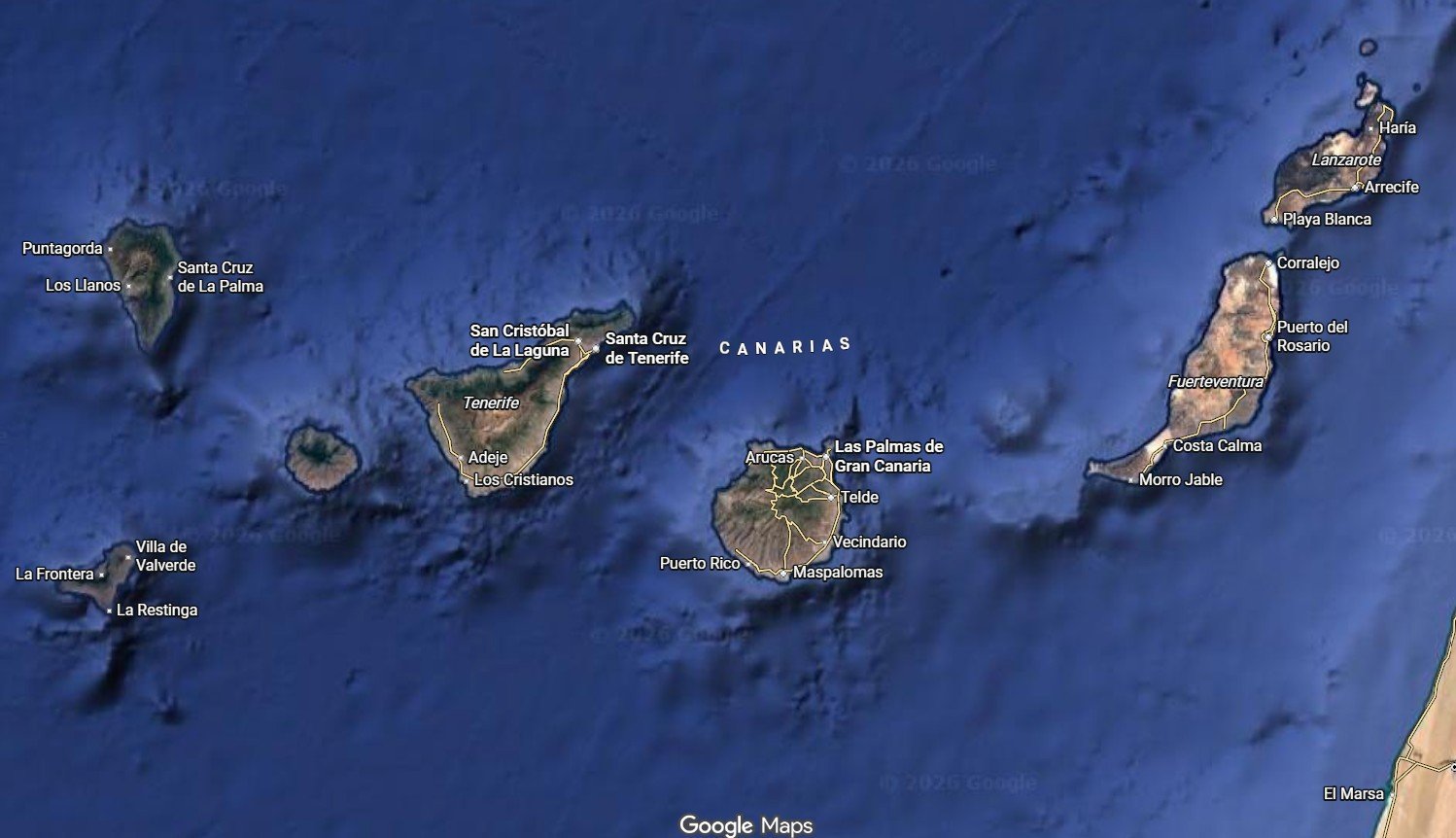
Google Maps screenshot of the Canary Islands. La Palma, to the NW is shaped like an almond, La Gomera (to the left of Tenerife) and Gran Canaria look like fruit squeezers.
The western islands are lush and green on the north and west sides, and barren on the south and east side. The two easternmost islands are barren, due to low relief and little moist. The black field on Lanzarote is the lava from the 1731-36 eruption.
The western islands rise from the depth of the sea floor, while the two easternmost islands sit on the edge of the African continent.
The Canaries are part of a larger area covering this eastern part of the Atlantic, called the Macaronesian hotspot province. It also comprises the Cape Verde islands, the Azores, Madeira and numerous submarine seamounts, and all this volcanism is tied together. Many of these islands form an arc-like pattern from west to northeast, like the Canaries, suggesting a common influence by the movement of the African plate. But, each of the hotspots are somewhat individualistic.
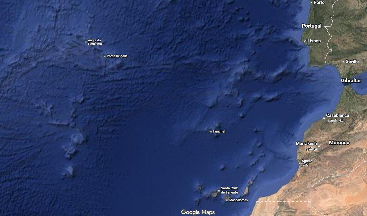
Google Maps image of the Macaronesian hot spot province. The Azores, up to the left, sit near the triple junction of the mid-ocean ridges. The Canaries, Madeira (with the capital Funchal on the map), and other smaller hotspots all exhibit a trend of seamounts following an overall E-W trend, which bends towards the NNE.
The reason is probably that each of these hotspots are smaller blobs, ascending from a large, shallow mantle that lies below the area. There is still much to find out about this shallow mantle province and why it is there. But the TL;DR version is that the volcanism shifts because these, smaller blobs do not ascend in perfect order, but are more individual bubbles. These blobs, in turn, are diverged by the major fracture systems in the area.
The Canaries, sitting on the edge of the African continent, are likely shaped by the fact that a part of the mantle plume comes up under the continent, but finds the easiest way out by going west and up through the thinner ocean crust.
Leaving the nerdy tectonics discussion aside, the relevant bottom line here is that there is no place in the Canaries with a rift or sufficiently high temperature to make a geothermal power plant – and no water to drive it. There are a few places that are hot enough to heat water for heating purposes; like the summit of Teide, or the Timanfaya area from the 1731-36 eruption on Lanzarote. But there is no water to heat there.

The majestic peak of El Teide on Tenerife.
This means that the Canaries have a big energy issue. Granted, they don’t need to heat their houses like the Icelanders do. Many houses have solar water heaters installed. But for power generation they rely on imported hydrocarbons, previously oil, now mainly LNG. Partly to offset this dependency, wind turbines pop up. El Hierro is almost self-supplied with a combined system of wind power and hydroelectric pump and dump: Wind power pumps water up into reservoirs, which are released down through turbines during wind silence.
But El Hierro is an island of only twelve thousand people, only a fraction of the islands’ population of around 2.2 million. Tenerife and Gran Canaria are the big ones, with around 972 000 and 863 000, respectively, and need more heavy-duty power generation.
The geology thus explains why the Canaries heavily depend on imported energy, with tourism and agriculture as the main businesses: There is just no local energy available for industrialization.
Of course, there are other ways to wealth than heavy industry. The Canaries have also worked to position Las Palmas and Santa Cruz de Tenerife as offshore and shipping hubs, using their strategic location on the shipping lanes from Europe to the Americas, and on route to round Africa.
To offset the heavy dependence on hydrocarbon import, there has even been exploration drilling in the Canaries. Most of the islands rise straight from the seafloor, but the two eastern islands sit on the outer shelf of Africa, and their economic zone stretches onto the shelf. In 2015, the Spanish energy company Repsol launched a campaign find oil and gas east of Lanzarote, but the first well found only traces of oil and gas. The second planned well was called off, both due to the first failure and heavy protests on the Canaries, for fears that oil could pollute the shores and taint the islands’ reputation as a paradise tourist destination.
This fear is understandable, sure, but it makes this paradise dependent on import to churn the engine of society. At time of writing, the war between USA and Iran has closed the Hormuz Strait and put the whole world energy system in play, which illustrates the vulnerability of being do dependent on energy import.
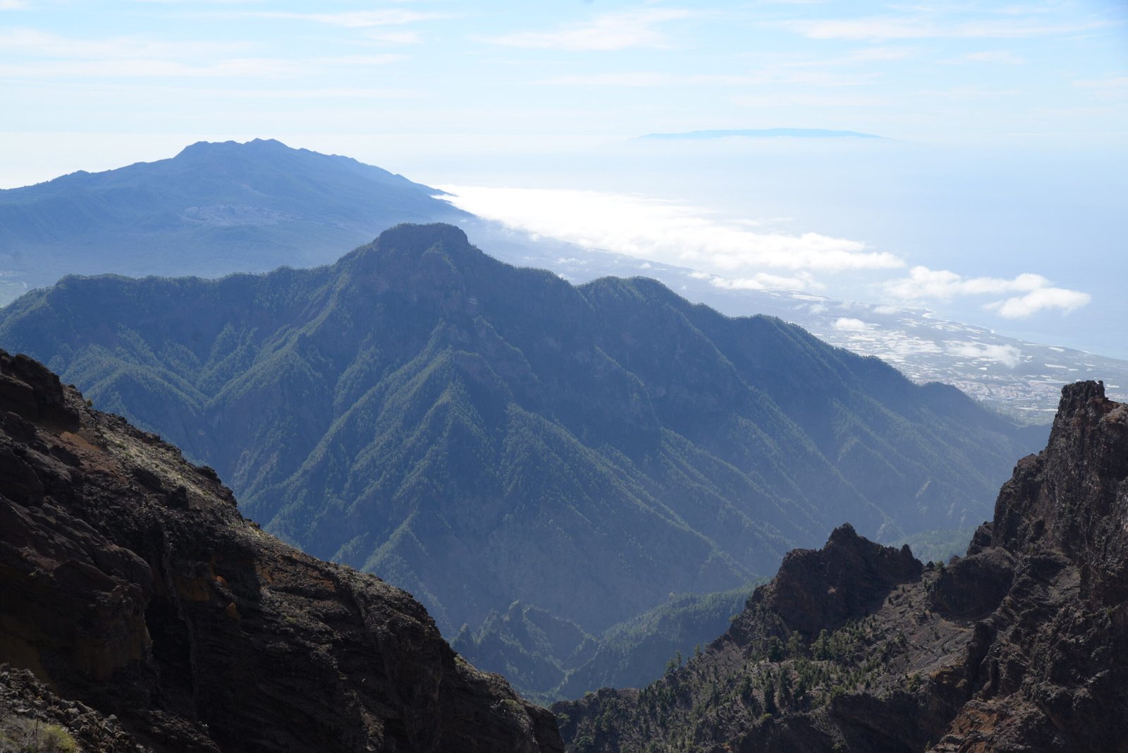
The Taburiente caldera on La Palma, with a part of the town Los Llanos — and on the horizon, the outermost island, El Hierro, seemingly floating in the haze. Lush, beautiful, but not a source of the energy a modern society needs.
This is my eighth time in the Canaries. Even if it was the first time on La Palma, it sort of feels like coming to my second, geological home, the sun, the volcanoes, the eternal breeze from the north, makes the islands a favorite place. But the geologist and energy nerd in me has always been interested in how their geology shapes the society. Life on La Isla Bonita is more complicated and less dolce vita than the glossy travel websites.
But it is also provides for a more interesting story.